Geographical Simulation and Optimization System (GeoSOS)
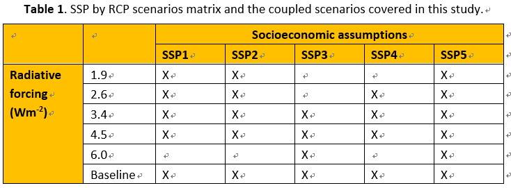
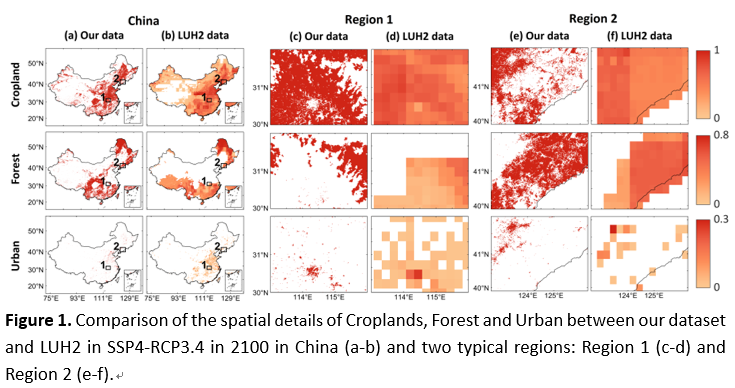
In the past decades, China has undergone dramatic land use/land cover (LULC) changes. Such changes are expected to continue and profoundly affect our environment. To navigate future uncertainties toward sustainability, increasing efforts have been invested in projecting China’s future LULC following the Shared Socioeconomic Pathways (SSPs) and/or Representative Concentration Pathways (RCPs). To supplements existing datasets with a high spatial resolution, comprehensive pathway coverage, and delicate account for urban land change, here we present a 1-km gridded LULC dataset for China under 24 comprehensive SSP-RCP scenarios (see Table 1) covering 2010-2100 at 10-year intervals with multiple LULC types (Cropland, Forest, Bareland, Grassland, Water, Urban, Shrub, and Ice). Our approach is to integrate the Global Change Analysis Model (GCAM) and Future Land Use Simulation (FLUS) model. This dataset shows good performance compared to remotely sensed CCI-LLC data and is generally spatio-temporally consistent with the Land Use Harmonization version-2 dataset while it can provide more spatial details (see Figure 1). This new dataset provides a valuable alternative for multi-scenario-based research with high spatial resolution, such as earth system modeling, ecosystem services, and carbon neutrality.
Gridded 1km Land Use/Land Cover Change Projections of China Under Comprehensive SSP-RCP Scenarios are available to download in: Here
Last updated: 18 June, 2021